Good morning
On 10 October 1970, Fiji became an independent country. This ended nearly a century of British rule over the Pacific island nation. The date marked exactly 96 years since Fiji had first become a British colony, in 1874.
Today's issue looks at borders, ancient cities and giant stones, and shows why some familiar geography facts are wrong.
In today's edition
- Italy's longest border runs beside an unexpected neighbour
- A Pacific city younger than you might assume
- Stone money carried 400 kilometres by canoe
- The Amazon's enormous flow into the Atlantic
- South America's northern tip belongs to Colombia
- Guess the mystery country before it's revealed
borders · Fact of the day
Italy's longest border is with Switzerland, not France
Most people would guess that Italy's longest land border runs alongside France, its larger, more familiar neighbour to the west. The true answer is Switzerland. The Swiss frontier measures about 800 kilometres, more than half as long again as the border with France, which runs for roughly 500 kilometres.
The reason is shape, not size. Switzerland is less than a fifth of Italy's area. But its southern edge is a long, winding mountain line that traces watersheds around several valleys. It dips down to touch Lake Maggiore and Lake Lugano, and even loops around Campione d'Italia, a small Italian town that sits entirely inside Switzerland. A jagged mountain boundary simply covers more ground than a straighter one, however small the country behind it.
↗ Send this fact to a friend6.86° N, 158.34° E · Place of the day
Nan Madol
Nan Madol is a ruined city built on more than 100 small artificial islands. It sits on a reef off Pohnpei, an island in the Federated States of Micronesia in the Pacific Ocean. Its walls are made of huge columns of dark volcanic rock, stacked without mortar.
People often assume a place built like this must be ancient, closer in age to Stonehenge than to anything in a history textbook. It is not. Scientists have dated the coral used in its oldest tomb to around the year 1200, which makes Nan Madol roughly as old as Notre-Dame Cathedral in Paris.
Workers hauled the stone columns from a quarry on the far side of Pohnpei to build the city, a feat of organised labour for its time.
 Play today's Worldle
↻ Also on the map
The Amazon pours more water into the ocean than any other river The Amazon River flows about 6,500 kilometres. It starts in the Andes mountains in Peru and crosses South America to Brazil's northern coast. Every second, it pours roughly 219,000 cubic metres of water into the Atlantic Ocean, more than the next several biggest rivers combined.
South America's northernmost point is in Colombia, not Venezuela Punta Gallinas is a headland in Colombia's La Guajira region. It is the northernmost point on mainland South America. It sits about 29 kilometres farther north than Venezuela's own northern tip, even though most people picture Venezuela's coast first.
Between issues
Fancy a different kind of puzzle today? GeoGrid gives you a 3 by 3 grid where each row and column sets a geography clue. Fill every square with a country that fits both its row and its column, without repeating an answer.
 Play today's GeoGrid
Locate the country
Today's mystery shape · 10 October 2026
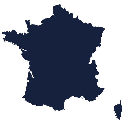
Today's silhouette is waiting for your guess. Study its outline, take your best shot, and see how close you get. We reveal the answer tomorrow.
Guess it on Worldle →Yesterday, revealed
Yesterday, 9 October 2026
It was Uzbekistan, Yesterday's silhouette tripped up plenty of sharp guessers, and that is half the fun. If you got it straight away, well done. If not, take another look at the shape and file it away for next time.
7.34° N, 134.58° E · By the numbers
Yap's stone money came from another island entirely
Yap, an island in Micronesia in the Pacific, is famous for giant stone discs once used as money. Its largest surviving disc is 3.6 metres across, about the width of a small room, and weighs 4,000 kilograms, as much as two cars. None of that stone came from Yap itself. The island has no limestone, so people quarried the discs on Palau, roughly 400 kilometres away, and carried them home by canoe and raft. The value of the money was tied to the distance it had travelled.
FREE · WEEKLY EMAIL · GEOGRAPHY
Put the world in your inbox.
A new geography brief on the site every day, and one in your inbox every week.
That's the world
See you tomorrow. The Teuteuf team
Sources: swisstopo (Swiss Federal Office of Topography), 'National border' · UNESCO World Heritage Centre: 'Nan Madol: Ceremonial Centre of Eastern Micronesia', World Heritage List no. 1503, Micronesia (Federated States of) · NASA Earth Observatory: "Amazon River in the Atlantic Ocean" · Wikipedia, 'Extreme points of South America' · Wikipedia: 'Rai stones'