Good morning
In 1609, Henry Hudson sailed his ship into a wide, unfamiliar harbor and found an island the local Lenape had already known and named for centuries. It was on none of the European charts he carried.
He put his own name on the river beside it; the island kept its older name a little longer than he expected. Today's edition is about that same gap between what's already there and what finally gets noticed: a Pacific monarchy, a redrawn date line and a lake count nobody finished.
In today's edition
- Where each new year actually begins
- The Pacific kingdom that outlasted colonization
- Three ways the world map changed
- Finland's real lake count revealed
- Nine squares, every one a country
- A mystery outline waiting for your guess
New Year · Fact of the day
This remote atoll beats Auckland to the new year
Every December 31st, the televised countdowns start in Auckland and Sydney, and it feels like the calendar turns there first. It doesn't.
Kiribati's Line Islands, including Kiritimati (Christmas Island), sit at UTC+14, the most forward time zone on the planet, a full hour ahead of New Zealand's UTC+13 daylight clocks. In 1995, Kiribati redrew the International Date Line more than 1,000 kilometres eastward so its remote eastern islands would share a calendar date with its capital on the other side of the country. As a side effect, a scattering of low-lying atolls rather than a headline city becomes the first inhabited place to greet each new year, an hour before Auckland's fireworks even start.
↗ Send this fact to a friend21.18° S, 175.20° W · Place of the day
Tonga, the Pacific kingdom never fully colonised
South of Samoa and east of Fiji, more than 170 volcanic and coral islands rise out of the deep Pacific, only a third of them inhabited. Tourists arrive expecting another postcard archipelago and find something rarer: a working monarchy that answers to no one else.
Tonga is the only Pacific nation never fully colonised by a European power, and the only one still ruled by an unbroken indigenous royal line. While Hawaii's kingdom was overthrown and absorbed into the United States, Tonga wrote the Pacific's first constitution in 1875 and has kept its own king on its own throne ever since, through two world wars and the collapse of every neighboring empire.
Find it on the map before you find it on a coin. King Tupou VI still appears on both.
 Play today's Worldle
↻ The feed · what moved
Everest's official height went up A joint Nepal-China survey fixed Everest's official height at 8,848.86 metres, nearly a full metre taller than the figure mapmakers had relied on for decades. Every atlas, wall map, and schoolbook chart printed with the old number is permanently out of date.
A volcano built an island Tonga's Home Reef erupted from the seafloor and pushed an island above the waterline in the South Pacific, complete with steaming black rock and, at the time, no name on any chart. It may erode back under the waves within a few years, but while it stands it counts as real, risen land.
Why Indonesia planned Nusantara Jakarta is sinking under its own weight and choking on gridlock, so since 2022 Indonesia has been building an entirely new capital, Nusantara, from scratch in the Borneo rainforest to replace it. It's one of the largest planned-city projects on the planet, designed to shift the country's whole center of political gravity.
Between issues
GeoGrid drops you into a puzzle where every square is a country, and every guess narrows the world a little further. It rewards the kind of half-remembered atlas knowledge you didn't know you still had (a shared border here, a coastline shape there) until the grid clicks into place.
 Play today's GeoGrid →
Locate the country
Today's mystery shape · 19 September 2026
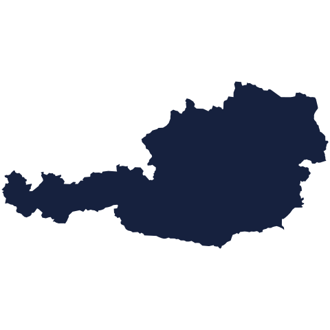
Today's silhouette waits below, borders and all, for anyone willing to look closely. Study the coastline, weigh the proportions, then commit to a guess. We reveal the country tomorrow.
Guess it on Worldle →Yesterday, revealed
Yesterday, 18 September 2026
It was Lesotho, Yesterday's outline sent plenty of guesses in the wrong direction before the right one landed. If your first instinct missed, you were in good company: the shape rewards patience more than confidence. The answer sits waiting below, whenever you're ready to check it against your memory.
62.40° N, 25.20° E · By the numbers
Finland's lakes, by the thousand
"Land of a Thousand Lakes" is one of the great national understatements: Finland actually holds nearly 188,000 lakes larger than 500 square metres, almost 188 times the number in its own cheerful nickname. Fly over the south of the country in summer and the ground looks less like land with water in it than water with land floating in it. With a population of about 5.5 million, that works out to roughly one lake for every 30 Finns. That's enough water and shoreline that no cartographer could ever finish naming them all, let alone counting the smallest ponds twice.
FREE · DAILY · GEOGRAPHY
Put the world in your inbox.
One surprising, entertaining geography brief each day. No spam; just a better sense of place.
That's the world
See you tomorrow. The Teuteuf team
Sources: Wikipedia: Time in Kiribati / UTC+14:00 · timeanddate.com: Line Islands Time (LINT) · Encyclopaedia Britannica: Tonga: History · RNZ (Radio New Zealand): About Tonga · Wikipedia: Tonga